
Edge shot from AER application maps
He unwittingly showed them
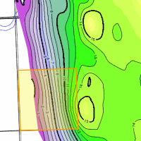 While applying for an modification to a mature water flood, this operator gave away several edge shots. His mapping has changed since the unit was struck many years ago. New mapping shows opportunities at the edge of his unit. He unwittingly showed these opportunities in mapping that he included in his routine water flood application. We found this using AppIntel.
Any geological or geophysical data you add to an AER application is in the public domain the minute you apply. Always use any contour options available to map your pool onto your own land. Otherwise you may encourage someone to put another straw in your pool.
Each AER application contains your neighbor's perspective on the exploitation of oil and gas formations. Applications contain more technical data even than CSPG papers.
Would you like to see what other operators in your areas are thinking about seismic, multifractured wells, polymer schemes and recovery? AppIntel can help.
Subscribers can view this application by pasting the following link into their browser after logging into AppIntel. app.appintel.info/AOW.php?pxnrg=48776y35323635313138355531
Tags: Flood, Exploration
 Granger Low 1 Mar 2016


Can we save the world by sequestering CO2?
Plans to store millions of tons of CO2

Save the world by recycling produced brine
Saline water treatment

AppIntel AI: Work smarter, not harder
Those that can't see the value of a car should walk

4 ways to be smarter in an age of information overload
Stay relevant with the right information

Sulphur plant turndown
See his process flow diagrams
 Calgary, Alberta, Canada
 Share
Share